With this cell I'm not only picking up possible quarter sized hail but also winds near 50 mph are likely! This cell is about to head into Wingate, and Mellott, in Fountain county. It is moving north north east at around 35 mph.
Wednesday, May 25, 2011
This severe thunderstorm warning was issued do to the possibility of quarter sized hail!
* SEVERE THUNDERSTORM WARNING FOR...
NORTHWESTERN CLINTON COUNTY IN CENTRAL INDIANA...
FOUNTAIN COUNTY IN WEST CENTRAL INDIANA...
NORTHWESTERN MONTGOMERY COUNTY IN WEST CENTRAL INDIANA...
TIPPECANOE COUNTY IN WEST CENTRAL INDIANA...
* UNTIL 830 PM EDT
* THE SEVERE THUNDERSTORM WILL BE NEAR...
HILLSBORO...WAYNETOWN AND MELLOTT AROUND 745 PM EDT...
WINGATE AND NEWTOWN AROUND 750 PM EDT...
NEW RICHMOND AROUND 755 PM EDT...
LINDEN AROUND 800 PM EDT...
SHADELAND AROUND 810 PM EDT...
PURDUE UNIVERSITY AROUND 815 PM EDT...
DAYTON...LAFAYETTE AND WEST LAFAYETTE AROUND 820 PM EDT...
BATTLE GROUND AROUND 825 PM EDT...
The Latest
Yes, we have seen some clearing skies in parts of the viewing area. I have been watching our temperatures in the Lafayette, area go from 63* degrees back up to 70* degrees in a matter of a few minutes! This is gonna keep the fuel going on this severe thunderstorm fire.
This round coming up tonight will be the main round to watch.
We are pulling a lot of warm air in from our south and cooler drier air from our north west. So this is a classic severe event. The good news is I have not received any tornado reports from this line since it has entered the IL, area. However we will be keeping our guard up! I still expect the main tornado event to be to our south and southwest however we will be keeping watch.
I still have LI values around -5 to -6 which is still pretty unstable.
I will continue to keep watch and keep you posted.
Head over to the chat and keep everyone posted on your area! ;)
And now that storm that gave way to a severe thunderstorm warning in southern Fountain county has now given way to a tornado warning with it as well. Take a look below. At this time this cell is still not in the viewing area. However because it is a strong cell we will be watching it closely overtime!
* TORNADO WARNING FOR...
SOUTH CENTRAL FOUNTAIN COUNTY IN WEST CENTRAL INDIANA...
* UNTIL 715 PM EDT
~~~~~~~~~~~~~~~~~~~~~~~~~~~~~~~~~
~~~~~~~~~~~~~~~~~~~~~~~~~~~~~~~~~~~
~~~~~~~~~~~~~~~~~~~~~~~~~~~~~~~~~~~
We have one current warned cell heading into the vieiwng area. It is for Fountain county until 6:45pm EDT. This cell could currently give way to winds of 50+ mph and possible pea to quarter sized hail.
* SEVERE THUNDERSTORM WARNING FOR...
SOUTHWESTERN FOUNTAIN COUNTY IN WEST CENTRAL INDIANA...
Latest Data
Okay. After going through some more data here's how things look currently.
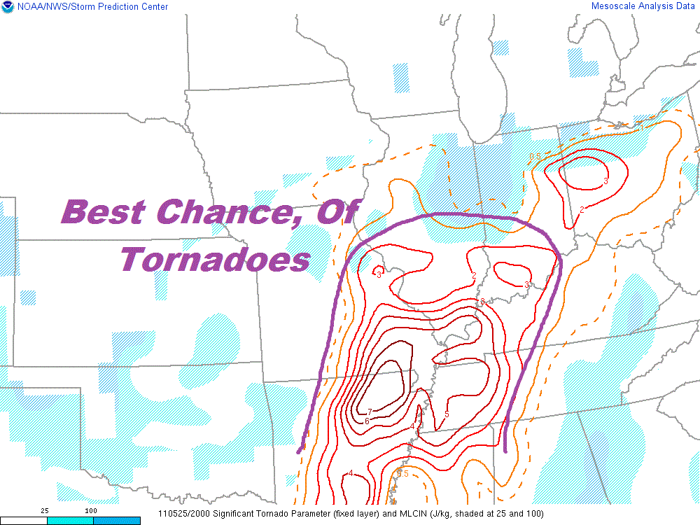
As you can see above our EHI values have started to improve! They're not as unstable as they were earlier this morning / afternoon. This is good news! Also we are starting to lose that daytime heating that helps to keep us unstable. Our temperature has started to fall from a high this afternoon in the 60s and 70s. To a current temp of 63* degrees.
At this time I'm still looking for the best chance of tornadoes to be to our south. Yes, inside the purple area you see in the image above. Now this does not mean we can't see one! It is still possible. However this is where I feel the best chance of tornadoes is currently going to be. So we will keep watch.
Also even though we are slowly trying to get a bit more stable. Some areas are not! Our Lifted Index (LI) is still very unstable at around -6. Anything from -4 and lower is very unstable! And that's why scattered pop up thunderstorms are likely this evening / tonight with a stray strong storm also possible.
So what we can do for now is just continue to watch the data and the radars closely. I will be here keeping everyone posted. You can do your part by letting other bloggers know whats going on near you by using the Live Chat on the top right of the blog!
Stay safe! I'll keep checking back.
Subscribe to:
Posts (Atom)