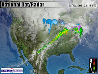
 Hey there above is a look at the radar image as of 6:50PM you can see the line of rain and thunderstorms starting to take form. Now this image looks more scary them it really is. So for you to know I'M currently not picking up any lightning other then a few strikes south of MO, around Arkansas, Which is still where I'M expecting the strongest of storms.
 We are starting to see more little bands of showers start to move into our area which from now until midnight we can expect more rain to come! I currently have already seen rainfall of .60" inches with more on the way. I still like rainfall totals to be around an inch to an inch and a quarter possible in the Lafayette area. We have already seen amounts around three inches up north in areas of Jasper county!
I will be back a little later on again with another update on the line of Scattered thunderstorms and an update on the River levels. Stay tuned..........

No comments:
Post a Comment