
Today. We will see highs in the upper 50s with lots of Partly Cloudy to deal with! This is a nice treat from nature after letting us off the hook from last night with all that rain staying to our south! Winds will be between 10 and 15 mph with a low in the low 30s.
Friday. A beautiful looking day with Mostly Sunny skies and a high in the upper 40s. Nice calm winds between 5 and 10 mph and a COLD LOW in the upper 20s! Not something we have seen in a short while! It will feel rather COLD after all those 60s and 70s we seen.
Saturday. The weekend is looking pretty good at this time with Partly cloudy to mostly cloudy skies which means we will see some off and on sun through out the day. A mild high in the mid 50s and a much better low in the upper 30s.
Extended Outlook. The models are being a little tricky with the timing of the possible rain showers for Sunday into Monday. As of now I think we will hold the rain off for Sunday until later on Sunday evening to that night into Monday! So Sunday is looking mostly dry at this time with Mostly cloudy skies.
Monday is when our next best chance for rain is. We will see highs start to go up once again to near 60* degrees. However rain is expected and as of now I cannot rule out a possible stray thunderstorm.
----------------------------------------
----------------------------------------
----------------------------------------
 Yes, for once Lafayette Indiana missed out on the wild stormy weather we all know oh to well. You can see in the radar image above that all the real stormy and heavy rainfall stayed to our south well to our south that is! We ended up with a tenth inch or less!! This is GREAT news for the area rivers once again. Currently the Wabash is at 14.26ft which is still a good three feet above flood stage. However it is expected to fall to near flood stage at 11.6ft by Friday 8:pm. This will be close to flood stage as flood stage is at 11ft.
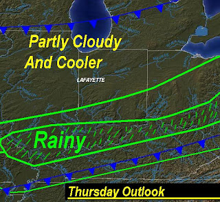 Now above is Today's outlook and this is just the picture! We will see the rainy stuff move out and the Partly Cloudy move in! Yes, the rain is pushing off to our east and the cooler weather will come in as well. It is looking like a great week however just a little drop in temperatures! Nothing major or bitter cold like we have seen this past few days but still we will feel it after having the past few days in the upper 60s to low 70s we all love so much..........We will see our high temperatures today in the mid to upper 50s and tomorrow highs in the mid to upper 40s with get this a low in the upper 20s! Good news is this won't last long with another slight warm up coming by Monday. Along with our next chance for some real rain and maybe a thunderstorm. I will watch this and keep you posted as it gets closer.
 My aunt Bomber sent me this picture of her Chihuahua Sophie last night and she calls her the taco Sophie lol. I think it is safe to say that Sophie is a little wore out after a full day of FUN and running all over that big yard she has! It is a Chihuahua's Dream! :) Thanks Bomber for sending me that GREAT picture! Be sure to tell Sophie she is looking good and to keep the pictures coming!!! ;)
Well, I do think we will see more of the nice weather we had this past week just a little cooler. So for the rest of this week I think it is a Partly cloudy forecast and we will be talking about more rain and a possible stray thunderstorm by the start of next week..........
No comments:
Post a Comment