

That's right a Winter Storm Watch has been put into effect for the following counties. carroll, Warren, Tippecanoe, Clinton, Fountain, And Montgomery , counties. This watch is in effect from Late Wednesday night into Late Thursday Night! I currently believe that the track of this winter storm will in time continue to track more north so I wouldn't be surprised to see the rest of the WLFI viewing area in this watch before long! So what is this winter storm? And how much snow could be on the way? Well, let's check it out!
I'm tracking a winter storm that will impact the area Late Wednesday night into Thursday! This storm could bring some significant snowfall along with it. Currently the weather models have the heaviest of snowfall to our south around I70 and so on. However I believe that this storm will continue to track more north! And if I'm right then that means deeper snow for the viewing area!
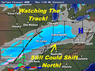
Above is a look at what this system may look like by Thursday around 7:am EST. This is where models currently put this storm. However like I said above I still believe that this system will continue to lift more north then what this image is showing. Allowing some of the heavier snow to move into the viewing area. I have gone ahead and put together a snow cast map to give you an idea as to what the weather models are currently showing snowfall - wise. However at this time I'm thinking that by tomorrow I will be upping these expected snowfall numbers! ;)

You can see models are showing me a 1" to 2" inch range north of Remington, with the northern half of the viewing area in a 2" to 4" inch band. The southern half of the viewing area around that 2" to 4" inch range and the 3" to 5" inch range. And anywhere from I70 south in the 3" to 5" and 4" to 6"+ inches. Now as with the last rain system we just seen over the last day or two lifting to the north we could be moving some of the heavier bands of snow in the image above that are currently south of the viewing area up north into the viewing area. So you can bet that I will stay on top of this storm and have another update tomorrow evening with a new updated snow cast map. Some models already have us in slightly higher amounts then what I have posted above however I will wait until tomorrow before I up them again!
Now let's take a look at the forecast break down.
Quick Cast.....
Wednesday we will look for mostly cloudy skies across the viewing area. A few possible scattered snow flurries / snow showers are possible. Snowfall only around a trace. Less then a quarter inch. Highs will be around 27* degrees with lows that night around 16* degrees. Expect winds between 5 and 10 mph. We will look for more wide spread snow to move in Late Late Wednesday into early Thursday!
Thursday we will be tracking snow through out much of the day. Some models show the snow moving in between 4:am and 5:am EST Thursday morning. Snowfall between 3" and 4" inches at this time, However I'm expecting this system to continue to shift more north which would mean we may have to add to these snowfall numbers! Expect highs around 25* degrees with lows Thursday night COLD around 3* degrees! Winds will be light between 3 and 5 mph.
Thursday Is Forecast Focus..... (Watching Closely).
~~~~~~~~~~~~~~~~~~~~~~~~~~~~~~~~
~~~~~~~~~~~~~~~~~~~~~~~~~~~~~~~~~~~~~
And after the snow passes the area we will be tracking the COLD POLAR AIR that will move into the area. I'm talking about a high Friday of only 11* degrees with a low that night around 8* degrees! WOW This isn't even counting in the wind chill! So cold and snowy is the forecast this week. Stay tuned bloggers. I will be on top of this developing system and I will be sure to keep you posted!
Before I go I thought I'd mention that we could very well be looking at another chance of fog later tonight into the early morning hours! So again allow extra time in the morning and be safe.
Be sure to check back for one last look at the new expected snowfall amounts tomorrow evening before the storm!
Take Care!
3 comments:
Hey Justin! Just wanted to tell you thank you for posting your weather blog. I thoroughly trust your forecasts and look to them for information regularly. Now. Let's get that snow NORTH! lol
Did you say " upping these expected snowfall numbers "??? :)
Still waiting for that big snow drop!
Oh boy Justin, just the kind of weather you love.. If its going to snow lets just hope we all get a snow day LOL!
Post a Comment