Can you believe it is only 8 days til Christmas? Its coming very very fast. This is crunch time not only for the last minute shoppers but also for any meteorologist. The weather models are lighting up like lights on a Christmas tree. We have so much going on this week that could be the difference between a white Christmas and a green one. But before I get to that lets go ahead and look at whats in store for tonight.
I'm currently looking for dew points to drop around 35* degrees with an air temperature tonight around 36* degrees. So a foggy night / early Monday morning will be in the cards. Allow extra time to get where you need to be and be careful if you're out and about.
As we head into Monday we will look for mostly cloudy skies across the area with a high around 48* degrees. Winds will be light between 10 and 15 mph. Rain showers will try to move into the area later on Monday afternoon / evening. Rainfall will be between .10" and .25" inches. Expect a low around 32* degrees.
Tuesday we will see partly cloudy skies across the area with a mild high around 50* degrees. A low that night falling to 35* degrees. As we look ahead into later this week I do see temperatures trying to get back around normal after Thursday the 20th. Much cooler air will try to filter in.
~~~~~~~~~~~~~~~~~~~~~~~~~~~~~~~~~~~~~~~~~~~~
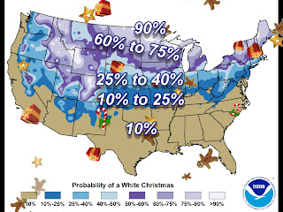
So how about our snow chances for Christmas? Well, right now we have so many different model readings telling us different things. I really cannot set anything in stone just yet. However I do agree with the National weather service's thoughts on our chances of a white Christmas.
Above is a chart showing our White Christmas snow chance. You can see we're keeping that 60% to 75% and 90% percent chance well north of our area. With Indiana, and much of the lower midwest in that 25% to 40% percent chance. You may think "25% to 40% percent is a pretty wide window?". And you're right! However at this time the models are still unsure how things'll play out.
Right now we have colder air that will try to filter in as we head into December 20th. Once this happens we will also have at least two shots at some snow showers in the area before Christmas. The question is "Will it be enough for coat the ground?". We have a chance of snow showers in the area between December 20th and the 21st, with another chance of some snow showers on Christmas eve. Things are to inconsistent at the moment to set any forecast in stone. I have watched these systems change so so much over the past few weeks. All we can do now is continue to watch them closely and forecast them as best to our ability as we can with the information we currently have. This is why we currently have such a wide window with that 25% to 40% percent chance of a white Christmas. I will be able to dial this forecast in much more as we head closer to the big day!
Here are a few snow extremes from Christmas Day's past:
Greatest Snowfall on Christmas Day
|
Greatest Snow Depth on Christmas Day
|
5.9” in 1909
|
9” in 2004
|
4.4” in 1926
|
7” in 2002
|
3.3” in 1890
|
7” in 1909
|
2.6” in 2005
|
6” in 1995
|
2.4” in 1935
|
6” in 1935
|
Have a great day bloggers. I will check back real soon.


2 comments:
www0605
ray ban sunglasses
soccer jerseys
ugg outlet
cazal sunglasses
coach outlet online
mulberry outlet
tory burch outlet
mishka clothing
keen shoes
michael kors uk
yeezy shoes
chrome hearts outlet
supreme new york
curry 6
balenciaga speed
off white nike
goyard
nike shox for men
supreme t shirt
converse outlet
Post a Comment