Saturday, October 31, 2009

Happy Halloween Everyone! :)

HAPPY HALLOWEEN BLOGGERS!
Well, it is finally here. Yes, it is Halloween and I have a treat this year weather - wise for all my bloggers. So lets get started! First off what are some of you doing this Halloween weekend? Maybe some Pumpkin carving? Some Halloween party's? Or how about some scary movies and lots of sweet snacks? If you have any outdoor plans will the weather allow them? That is the question and I have the answer. Real quick lets take a look at today's forecast below!Halloween Quick Cast.
Today we will look for a treat rather then a trick! This already sounds good lol. We will start out with some cloudy skies over the WLFI viewing area. However as the day continues we will see the clouds start to break up and become more clear. We will see Partly cloudy skies take over by this afternoon. Highs will feel much cooler then they did yesterday! I look for highs in the low to middle 40s around 45° to 46°F degrees. The good thing is winds won't be as high as they were yesterday! I look for winds between 10 and 20 mph. Lows Halloween night will be rather cold near freezing. Lows will be around 32°F degrees tonight. The trick or treat-ers may need a light jacket as they hit the streets for extra candy this evening...
~~~~~~~~~~~~~~~~~~~~~~~~~~~~~~
~~~~~~~~~~~~~~~~~~~~~~~~~~~~~~~~~~

For the way things look right now I think the weather will allow your outdoor fun today. Sure it is going to be a little cool however we can handle that. My sister and I made a harvest soup for All Hallows Eve last night for dinner and I have to say it was GREAT! Today on the other hand we will have lots of sweets to fix up along with adding a few more decorations before all the scary movies tonight. We usually stay up through out much of the night watching movies with no lights other then the Jack O Lantern till we can't watch anymore! lol. You can see we have already carved out the pumpkins below.

Sisters.....
Justin's.....
You should have seen my Sister carving her pumpkin lol. She was so grossed out by the inside mess I was laughing so hard... And that reminds me, Did any of you know you can eat the Pumpkin seeds? Our Mother told us about this a few years ago and now it is something we do just about every year. I have already been eating the seeds from my pumpkin the past two days. For those of you who don't already know they taste pretty much like a peanut. If you like peanuts then you should like baked pumpkin seeds. Here's how to make them below. Just make sure you don't tell my Mom I posted this lol :)

Pumpkin Seeds.....

Wash seeds after carving your pumpkin.

Dry on a paper towels.

When dry lay them on cookie sheets and sprinkle with a little salt. Bake in 225° degree over for 1 hour.
~~~~~~~~~~~~~~~~~~~~~~~~~~~~~~
~~~~~~~~~~~~~~~~~~~~~~~~~~~~~~~~


Then all you have to do is grab your seeds and enjoy! I love em! One thing I wanted to do this year was find out the real meaning of Halloween. What it is about and how it got started. I thought I would post a little something about it below so you all can know what it is really about and how it got started as well. It's pretty cool how much holidays change over the years.The History Of Halloween

Halloween's origins date back to the ancient Celtic festival of Samhain (pronounced sow-in).

The Celts, who lived 2,000 years ago in the area that is now Ireland, the United Kingdom, and northern France, celebrated their new year on November 1. This day marked the end of summer and the harvest and the beginning of the dark, cold winter, a time of year that was often associated with human death. Celts believed that on the night before the new year, the boundary between the worlds of the living and the dead became blurred. On the night of October 31, they celebrated Samhain, when it was believed that the ghosts of the dead returned to earth. In addition to causing trouble and damaging crops, Celts thought that the presence of the otherworldly spirits made it easier for the Druids, or Celtic priests, to make predictions about the future. For a people entirely dependent on the volatile natural world, these prophecies were an important source of comfort and direction during the long, dark winter.


To commemorate the event, Druids built huge sacred bonfires, where the people gathered to burn crops and animals as sacrifices to the Celtic deities.
During the celebration, the Celts wore costumes, typically consisting of animal heads and skins, and attempted to tell each other's fortunes. When the celebration was over, they re-lit their hearth fires, which they had extinguished earlier that evening, from the sacred bonfire to help protect them during the coming winter.


By A.D. 43, Romans had conquered the majority of Celtic territory. In the course of the four hundred years that they ruled the Celtic lands, two festivals of Roman origin were combined with the traditional Celtic celebration of Samhain.

The first was Feralia, a day in late October when the Romans traditionally commemorated the passing of the dead. The second was a day to honor Pomona, the Roman goddess of fruit and trees. The symbol of Pomona is the apple and the incorporation of this celebration into Samhain probably explains the tradition of "bobbing" for apples that is practiced today on Halloween.

By the 800s, the influence of Christianity had spread into Celtic lands. In the seventh century, Pope Boniface IV designated November 1 All Saints' Day, a time to honor saints and martyrs. It is widely believed today that the pope was attempting to replace the Celtic festival of the dead with a related, but church-sanctioned holiday. The celebration was also called All-hallows or All-hallowmas (from Middle English Alholowmesse meaning All Saints' Day) and the night before it, the night of Samhain, began to be called All-hallows Eve and, eventually, Halloween. Even later, in A.D. 1000, the church would make November 2 All Souls' Day, a day to honor the dead. It was celebrated similarly to Samhain, with big bonfires, parades, and dressing up in costumes as saints, angels, and devils. Together, the three celebrations, the eve of All Saints', All Saints', and All Souls', were called Hallowmas.
~~~~~~~~~~~~~~~~~~~~~~~~~~~~~
~~~~~~~~~~~~~~~~~~~~~~~~~~~~~~~~


And now you know the truth of Halloween. So many people have so many different takes on this very holiday which is just fine! But now you know how it really got started and what it is really about. Now have a very Happy and Safe Halloween Bloggers. I'M off to enjoy and get ready for a Halloween movie night with lots of snacks lol. Anybody want some? ;) Have a great weekend....................

Friday, October 30, 2009

Heavy Rain In The US Today. Some Areas Got Hit MUCH HARDER Then Other!

Heavy rainfall all over the central parts of the states this morning continues from last night. Some areas hit much harder then others that is for sure. First off I want to start with letting you all know the latest watches warnings and advisories. Benton, Newton, and Jasper, counties that was under the Flood watch last night is no longer under that watch. The National Weather Service has changed that to a Flood Advisory which is in effect from now until 1:45pm CDT or 2:45pm EDT. Currently no other counties in the WLFI viewing area are under any flood watches warnings or advisories at this time which is always good to hear! However all of the WLFI viewing area has seen rain as they went out and checked the gauges this morning. Here are just a few quick numbers from this morning below.

Rensselaer, 1.22" Inches

Kentland, 0.98" Inches

Lafayette, 0.60" Inches

Mellott, 0.50" Inches

Attica, 0.23" Inches

Williamsport, 0.21" Inches
~~~~~~~~~~~~~~~~~~~~~~~~~~~~~~~~
~~~~~~~~~~~~~~~~~~~~~~~~~~~~~~~~~~~
You can see that Rensselaer, comes in the the current highest of today with Kentland, not far behind with 0.98" Inches. I will have more rainfall totals posted later on from around the area. Now some states have not been as lucky as we have when it comes to rainfall amounts! I have seen a few other reports from areas of MO, where they have had rainfall just over night from anywhere between 2.71" Inches all the way up to 4.22" Inches dumped. And it gets worse! If we go a little more south to areas of AR, then we will see rainfall dropped over night between 4.78" Inches to an unbelievable 5.19" Inches of rain and it is still coming down in these areas! They can look for another half inch to and inch and three quarters on top of what they already have! This is where the real flooding is / will be taking place! Above you can see this radar image taken earlier on this morning around 9:14am EDT. This is all the rain forming along that cold front. What is going to make this system such a wet and dangerous flooding system for so many others to our south is because it is moving slowly to the north north east. You can see the way it is moving in this image above. Basically training rain.You can see all the moisture it has been pulling up from the golf as it continues to move to the north north east. You gotta feel for everyone that this system has effected to our south as there were five tornadoes reported in LA, alone yesterday! With another two reported just to there north in AR. Here are the reports from the LA, area below.

Tornado Reports From LA,

NUMEROUS HOMES DAMAGED FROM A TORNADO SPOTTED BY A SCHOOL SUPERINTENDENT. TREES WERE DOWNED ALONG I-20 BLOCKING ALL EASTBOUND LANES.

SIGNS TORN UP AND AUTO DEALER ON FIRE OFF I-220

POWERLINES DOWN AT THE INTERSECTION OF WEMPLE ROAD AND OLD BROWNLEE ROAD. OVERTURNED TRAILER NEAR OLD BROWNLEE ROAD

EYE WITNESS REPORT OF A TORNADO IN PLAIN DEALING. MULTIPLE REPORTS OF TREES DOWN INCLUDING TREES DOWNED ON A HOME. SEVERAL REPORTS OF TREES DOWNED IN THE MOT COMMUNITY

STEEPLE ON CHURCH IN DOWNTOWN SHREVEPORT TORN OFF AND ONTO A CAR
~~~~~~~~~~~~~~~~~~~~~~~~~~~~~
~~~~~~~~~~~~~~~~~~~~~~~~~~~~~~~~


And last but not least this is a report that really gets to you. This is a wind report from Vivian Caddo, LA. The wind speed was not known.

*** 1 FATAL *** TREE WAS DOWNED ALONG HWY 1 NEAR VIVIAN AND A VEHICLE STRUCK THE TREE KILLING THE DRIVER. REPORT FROM LOCAL MEDIA.
~~~~~~~~~~~~~~~~~~~~~~~~~~~~~
~~~~~~~~~~~~~~~~~~~~~~~~~~~~~~~~


We need to pray for the people effected by these dangerous storms that struck the south last night! And just be even more thankful we only seen rain.....

Now as for how much more rain we will see today I think I will cut the totals back a little. We was calling for near three inches however this time I think we will look for another half inch to maybe an inch and a half on top of what we already have. Wind I'M also cutting back this morning. Yes, I'M just changing our forecast for the better lol. I had been looking at winds between 40 to near 50 mph. However I have gone through the latest data and I think we will keep them between 30 and 35 mph today. The main low pressure system is setting up a little more north and west then first expected. There for we will still see winds however the highest winds or the main target will now be more north around areas of Northern Illinois, or Wisconsin as well as Minnesota, for sure!

So stay dry and stay safe. Be careful driving on the roads as there will be lots of leaves down. Even more on the neighborhood roads and that will make thinks slick! Wet and leaves don't mix very well... I will check back as needed.

Oh before I forget. I will be back with your Halloween forecast later on tonight. Thanks for reading....................

Thursday, October 29, 2009

Nightly Update. The Rain Is Only Going To Get Heavier!

I'M back with the nightly update on this rain that is over taking the WLFI viewing area. We have flood watches and Flash flood warnings out to our east with Flood warnings to our south. However three of our northern counties are under a flood watch. The counties of Benton, Newton, and Jasper, are in this flood watch from 7 PM CDT /8 PM EDT/ This evening through Friday evening... The rest of the viewing area has flood watches / warnings posted all around us. This is a RAIN PACKED SYSTEM that is for sure. Take a look at this radar image I have posted below.This image was taken at 8:05pm EST this evening. You can see all the mess heading this way. I don't look for anything severe thunderstorm - wise which is always good news! However there are many many severe thunderstorm warnings as well as tornado warnings posted well to our south in areas of Texas, Louisiana, and Arkansas. This is where all the severe weather has been expected and looks to be taking place. Lafayette, on the other hand has some heavy rain and strong winds to watch out for. I still call for rainfall between 1.50" and 2.50" inches with still locally higher amounts on top of that!! Be ready to report your final rainfall totals.....

Winds will not be much better as after looking at the latest model data I have winds forecasted between 35 and 45 mph some could gust closer to 50mph in open areas. This is going to be a wet windy storm.

I will check back as needed. Be ready as the rain will only get heavier as the night goes on into Friday..... Stay put and stay dry bloggers.

We Go From Autumn To Winter. Where's The Snow?

Again the main topic today has to be Friday's rain and windy mess. To start we already have Flash flood watches in effect for nine states from TX all the way north east to south parts of Indiana. And we can only expect more to pop up between now and Friday! Can you tell already that this system is going to be a rain dumper? :) I made a quick map below to help show some of what the models have been pointing out. Let's take a look.You can see the main low pressure system. It is expected to set up to our north as you can see in the MN, area and then move just north east of there. This is when we will see the gusty winds take place in the WLFI viewing area. Still at this time I'M looking at rainfall between 1.50" inches and 2.50" Inches in local areas. Winds on the other hand are still looking breezy with gusts between 25- 35mph maybe a little higher in open field areas.

Today we will start out with AM, sun. Then as we head into this evening / tonight we will see the clouds move into our area followed by the rain soon after. We will then look for the rain through out the night into Friday. With all this mess expected to start later on tonight into Friday I will check back with another update soon.
Until then I ask you all "Have any of you been out raking the lawn yet?". Well, I was out raking again yesterday with my sister and I found one of the biggest leaves I have ever seen. And yes, I had to take a picture lol. Can you tell I have nothing to do with my afternoons? LOL :)
Maybe it's a little odd that I'M really amazed by this leaf however I don't really care Ha Ha. This leaf from tip to the bottom of the stem is an amazing ten inches! Now what's the record for biggest leaf? Hummmmmmmm........ :) You can see why this one really stood out from the others. If any of you have a leaf bigger then ten inches from tip to the bottom of the stem then sent it in to me at storm18mini@aol.com I would love to see. If its really big I may post it.

Now lets go from autumn to winter! If I remember right then in three days it will be November 1st. Which means snow won't be far off! I know many of you run off in fear of the word snow, However it is on the way as winter comes fast! So what are we looking at below? Well, where is the snow is now in the USA.
That's right we have Winter Storm Warnings all over the western parts of the USA. And you can see why above. Areas of North Platte NE, are looking for one to two inches of snowfall today with another one to three inches expected tonight. However this snow does not make it a snow storm now does it? We have to add in the expected winds which look between 25 and 30 mph blowing the snow all over the place! And if this is not enough. They are expecting lows in the low 20s around 20° to 22°F degrees at the most. This will make it feel like 0° to 1°F degree with wind chill. It will feel so cold that people will walk out to look at the temperature and come back in and say "There isn't one" Now that's cold lol :)
I will check back real soon with more details on what we can expect for Friday.
See ya then..........

Wednesday, October 28, 2009

A Detailed Friday Forecast And A Sneak Peak Into Halloween..... A Forecast You Don't Want To Miss!

Hey bloggers. I'M back with a full weather update and we will talk details about Fridays forecast. I can tell you it is looking WET AND WINDY!!!!! That is for sure. I have some weather models I would like to show you however I will break them down and everyone will be able to understand what I'M talking about / showing you. I promise ;)

First off let me go ahead and let you all know about today's outlook as well, as Thursday. Today we will be looking for a few left over showers to finish moving through the area this early morning. As we head into the early noon hours we will see things start to look better with mostly to partly cloudy skies. This will hold up into Thursday.

Thursday we will see skies really try and clear out with partly to mostly clear skies over the WLFI viewing area. With clear skies like this we will see highs kick up to the upper 60s near 70°F degrees. This will be a nice treat you many of you. We will however see clouds slowly move in later on Thursday night into Friday. That is when we will see things really kick up! Take a look at this below.You see that low pressure system to the north of this image, (Look just north of MN) This is what will cause many of our problems this Friday. You can see as this low pressure system moves north of our area we will see these isobars get really close together. As many of you know when we see isobars packed like this it can only mean one thing! You guessed it. WIND! However you can also see in this GFS model, All the cooler temperatures to the west of Indiana, just inching there way closer and closer. Once the cold front finally makes it's move on us after Friday we will see temperatures fall from the low 60s to the middle 50s to the low 50s to the upper 40s in a matter of three or four days.
As for the wind issue we can see above that we will need to tie things down! I know this model is a little hard to read / see because I had to make it smaller to fit in the blogger box. However I will tell you what we are looking at! You can see the Yellow to light orange colors over the Midwest area. This is where Indiana / Lafayette, is. What this model is showing us is the possibility for 40 to 45 knot winds. Which when in Mph becomes between 46 and 52 mph winds! And this 850 mb model is not the only one calling for high gusty winds at this time. I also have Bufkit models showing me winds gusting between 40 and 45 mph on Friday. As you all know this is not set in stone at ALL! However I just wanted to show you all what I have been looking at the past few days.

And if this windy mess is not enough then take a look at what I got for you below.Yes, with all the blowing wind I also have current expected rainfall between a Half and one inch. However at this time it is "Very" possible for it to go higher. It's just at this time calling for more would be a stab in the dark. It's still to early. But I think this is a good starting point for rainfall amounts on Friday. I will continue to watch this developing system as well as continue to keep you all posted with the latest! This is just a post of what we are currently looking at. I expect things to change as it gets closer and that is why I'M here! To let you know the changes.....

Now last but now least lets take a quick sneak peak into the Halloween forecast. Is it a trick or a treat? Halloween is looking like a treat this year for a change! Currently looking rather dry after Fridays storm pushes off to the east. Winds will die down and we will look for some mostly to partly cloudy skies. The main thing we need to check on is the temperatures right? For all the trick or treater's. Well, highs I think will range in the upper 50s with a low that night in the low 40s. Maybe a light jacket for the younger kids. I also forecast lots of Fun and Candy. Now that is a forecast we can count on! lol. :)

Thanks for reading bloggers. I will check back soon..........

Tuesday, October 27, 2009

No Computer Means ((ANOTHER)) Short Update.....

Well, bloggers this is going to be yet another short quick update. I'M sorry about all this however I cannot get on my computer once again to do the blog update. Everyone in my house has been on my phone line. So I have to use my sisters.computer and she has NONE of my weather maps, skins, backgrounds, or anything like that, there for I cannot post any maps to help show you all what is expected today into Wednesday. I have no idea as to when I will be able to give good updates again I just hope you will hang with me. It is getting harder and harder to keep this blog going without being able to do it from my pc. But anyway you all don't want to hear me Blab on about that stuff so here is just a quick cast blog cast below.

Today we will look for partly to mostly cloudy skies over the WLFI viewing area. As we head into this afternoon to this evening we will see rain start to move in. I expect to see rainfall any ware between a quarter and a half inch. Highs today will be mild in the middle 50s. Not bad not bad at all.

Wednesday we will start off the day with a few left over showers possible however this will not last long or all day for that matter. We will see clouds start to break as the day goes on and we will then become Partly cloudy over the WLFI viewing area. Highs will be warm once again in the low 60s with lows that night in the middle to upper 40s.
~~~~~~~~~~~~~~~~~~~~~~~~~~~~~
~~~~~~~~~~~~~~~~~~~~~~~~~~~~~~

Now temperatures this week after today will be in the middle to upper 60s near 70 degrees. This will last into Saturday. Then as we hit Sunday and the start of the next work week we will see highs fall back into the middle 50s once again. It is this time of year we usually see these temperatures swings.

Our next chance at a good rainfall after today will be near the end of this week. Yes, Friday is the next tracking day. We will see a big cold front make a move on us bringing a line of heavy rain along with it. A ruff idea or rainfall amounts at this time are around an inch with locally higher amounts possible, However this is still many days away and I will have more updates on that as it gets closer.

That's all I have for now. Sorry it is so short. Just be glad it's not storm season, In which I would have nothing. No radar, No nothing! Hopefully I'll be able to use my pc again soon. Thanks for reading. I'M off to work for the neighbors!

Stay Dry.....

Monday, October 26, 2009

How Was Your Weekend? Did You See Jupiter? You Will Get Another Chance Tonight!

Everyone enjoy there weekend? Well, we have a little bit of rain to talk about today into Wednesday. As you can see above there will be a slight chance for a stray scattered shower to move through parts of the WLFI Viewing area later on. Nothing heavy in the least bit which is good news. Rainfall would be around a tenth inch or less. This line is what will be the rain threat for tomorrow. Again not expecting to see much in the way of rain. Later on Tuesday night into Wednesday is when we will see the much better chance at some rain to move through the area where we will see rainfall amounts between a quarter and a half inch possible. And I will have more on that a little later. So what did I do on my weekend? Take a look above and below. After watching the Sunday football game between the Rams and the Colts I headed out to see what kind of fall pictures I could get. This believe it or not is just from around my neighborhood. This is the most colorful autumn I can remember in a long time.And what helps these pictures stand out was the blue sky in the background that is for sure! It was a perfect autumn day.
And I cannot forget what treat we had on Saturday night! Remember we talked about the moon and Jupiter being side by side on Monday/ Tonight? Well, that is still true. However you could still see Jupiter and the moon Saturday night looking south. They were not side by side however it was still an amazing thing to see through the scope. Take a look below. Now I would like to point out that Jupiter was more visible in person lol. I have a camera in my phone so it don't like to zoom to far. :) But you can still see the little dot lol. Here is a little closer picture below of Jupiter.Now if we see a break in the clouds tonight then remember to look in the south sky and look for Jupiter side by side the moon. You will know which one is Jupiter as it will look like a bright bright star.
I will check back in soon with a update on the rain coming by Wednesday. And maybe another warm up in time for Halloween! I will let you know if you should have the heavy Jackets on Halloween or not!

Saturday, October 24, 2009

Your Weekend Update Is Here! And The Parakeets Are Ready To Carve There Pumpkins!

What are we going to do this weekend? Well, we are going to enjoy the beautiful Autumn colors and all the falling leaves! My favorite thing to do is watch outside my window and see all the trees change. This is what I do daily while working on the blog post. However I'M not the only one enjoying the leaves this time of year.
Yes, this is a picture my Aunt sent in of her dog Archie. I know for a fact he always gives her a hard time. lol. I'M just thinking about the mess he is bringing into her house after all the rain we have seen this week! :) And what dog don't love playing in the leaves? I don't think I know of any. I do know every year I rake the back yard my dog always waits until I finish to jump in the pile and undo all my work! lol. You think I would learn to keep him inside by now. But who am I to take his fun away? :)

Even the Parakeets are getting into this Autumn weather! It is almost Halloween and they are ready to carve there pumpkins. ;-)
LOL I love this picture. Ziva, above is my sisters parakeet and as you can see she loves the camera! How can you look at this picture and not get a smile on your face? I can't do it. Ha Ha. My boy Memo, below is not as much of a fan of the camera as Ziva, is.
He loves the pumpkin however he is on the go 24-7 and would not stop moving for five seconds to get a nice picture! He's a little punk lol. And he knows it! ;) He has such a crazy one of a kind personality. This bird picks on my sister all the time. And I know what your thinking. "How does a little parakeet pick on a human?" Answer, EASY! My sister has rocks on a shelf on which she lets the birds sit. Well, Memo, thinks its funny to pick up the quarter size rocks and throw them at her while she works on the computer. And not just at her but right into her freshly poured glass of soda! :) And I cannot forget about the many fly by poops. LOL. Teri, seems to think I teach him to do these things! "Me?" Never..... Waaaa Haaa Haaaa ha. :D

Now let me get to your quick cast weekend forecast! LOL Fly by poops HA HA.......... Oak I'M done now! ;-)

Quick Cast Blog Cast.....

Today we will see AM, clouds and PM, sun. Once the morning clouds start to clear we will look for some Partly cloudy skies to over take much of the WLFI viewing area. Highs will feel rather cool as they are expected to be in the upper 40s closer to 48°F degrees. Lows will be in the low to middle 30s. We can expect to see winds between 10 and 15 mph.

Sunday we will have to keep a slight chance for some scattered showers to move in that night. We will look for Partly to mostly cloudy skies through out the day with a 20% to 30% chance of some scattered showers to move in later on that night into Monday. Rainfall is expected to be between a Tenth and a possible quarter inches in some areas cannot be ruled out just yet! Highs will be in the upper 50s with lows that night in the middle to upper 30s. Winds I expect to be between 10 and 20 mph.
~~~~~~~~~~~~~~~~~~~~~~~~~~~~~~
~~~~~~~~~~~~~~~~~~~~~~~~~~~~~~~~~

And last but not least in your weekend update I wanted to show you all, this below.

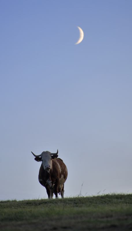
LOOK AT THE MOOOOON: "Last night while traveling through the Black Forest, we saw some cows on a hill with the crescent Moon behind," says German photographer Achim Schaller. "I laid down on the meadow with my Nikon D700 and photographed the close encounter."Another close encounter is just around the corner. The Moon is moving away from the cows of the Black Forest and toward the king of planets. Look for Jupiter and the Mooooon side by side on Monday evening, Oct. 26th:
~~~~~~~~~~~~~~~~~~~~~~~~~~~~~~~
~~~~~~~~~~~~~~~~~~~~~~~~~~~~~~~~~~
I show you this for two reasons! One, It's a beautiful picture! And Two, You will be able to check out the moon and Jupiter side by side on Monday night, looking south. (Monday Evening, October, 26th) The question is, "Will the skies clear out so we can view this?" Well, currently it is looking like some light scattered showers that afternoon to evening. So will the clouds move out before it's to late? We will keep hope that is for sure! So we will continue to watch Monday nights forecast to see if we will be able to view Jupiter and the Moon side by side... Just in case we can, Here is a Sky map link below. Be sure to check it out. Thanks you for reading Bloggers. Have a wonderful weekend and I will catch ya Monday! HAPPY WEEKEND..........

Friday, October 23, 2009

Big Rainfall Numbers Coming In From All Over The Viewing Area!

Well, we forecasted a lot of rain and that is just what we seen! Big rainfall numbers are coming in from all over the place. The good news is we did not see any flood watches or warnings this time around. They did continue to move north however none in the WLFI viewing area thank goodness. Most of the WLFI viewing area did stay under that two inch mark any ware between 1.41" and 1.96" inches. However there were a few that did break two inches in places like Logansport, and Kentland. Take a look at these numbers from around the area below.

Rainfall Totals.

Logansport, 2.06" Inches.

Kentland, 2.05" Inches.

Monticello, 1.96" Inches.

Lafayette, 1.85" Inches.

Remington, 1.83" Inches.

Attica, 1.65" Inches.

Williamsport, 1.14" Inches.
~~~~~~~~~~~~~~~~~~~~~~~~~~~
~~~~~~~~~~~~~~~~~~~~~~~~~~~~~~

Logansport coming in with one of the highest this time around. I knew after looking through the latest model runs that we could not call for anything less then close to two inches in local areas. And this rain also helped the leaves to really come down around that area that's for sure! We had them all cleaned up yesterday and now morning has come. It looks like we never touched them!

So after all the rain we seen through out last night the new question will be. "Are we going to see more today?" Well I have put together a quick map below to help answer your question. Take a look below.
Today we will see highs range in the low 60s so it will feel cool but not cold. I cannot rule out the chance for some hit and miss light scattered showers in areas of the WLFI viewing area as this cold front continues to make its way to our east. We will see cloudy skies through out today.

As this cold front pushes through the area we will see cooler temperatures take place tomorrow as I don't look for highs to get out of the 40s. Currently looking for a high Saturday of around 48°F degrees. The rest of the week is not looking bad temperature - wise. We will see temperature ranging between the upper 50s to low 60s which will be around average to slightly below. No big temperature changes at this time. Just remember to grab your jacket before you head out Saturday morning! ;-)

I will check back in with you all again real soon. Right now I need to pick up some Bird Seed for the Parakeets. They eat like there is no tomorrow! lol. Have a great day..........

Thursday, October 22, 2009

Keep The Umbrellas Handy, It Going To Be A Wet One!

Radar Image Taken At 11:07AM EST.....
Above is the close range look in IL, which is where the rain currently is. This is what we have to look forward to later this afternoon / early evening into Friday! I have been going through more weather data all morning and I'M here to let you all know that the expected rainfall totals have gone up from what we was calling for yesterday. We are now expecting to see rainfall between a three quarters of an inch to one inch with locally higher amounts closer to an inch and a half possible in areas. Some areas could see closer to two inches however this is hard to tell at this time. Areas who see training will see the BIG numbers! And I will have more updates as I get new data. Take a look at the national view below.

National Radar Image Taken At 11:11AM EST..... Just a lot of rain that is for sure. We are already seeing Flood warnings and flash flood watches posted for areas to our south in places like Louisiana, Texas, Arkansas, and areas of Mississippi. Earlier this morning flood warnings did not make it up to Arkansas, however as the day goes they seem to continue to climb north. We can expected rain to start this afternoon and continue into Friday. Keep the umbrellas handy and stay dry! It's going to be a wet one.

I will continue to check in off and on today as needed. Be sure to send in your rainfall final rainfall totals. And you can always send weather / Nature pictures to me at storm18mini@aol.com .

I will check back as needed.....

Wednesday, October 21, 2009

From 40s To 70s? Today Is The Warmest Day Of The Month!

We hit a high yesterday of 68.7°F degrees. For once we had a high this month that was average! This is not something we are use to lol. Believe it or not after having highs in the low 50s and upper 40s this past month, Having highs hit near 70° felt kinda warm. It got hot in the house last night. I'M sure many of you got a chance to got out and enjoy the nice mild temperatures right? That is if you could get past all the Yellow Ladybugs flying through the air. I have not seen this many in the Lafayette area in a few years. They have been all over lately. I really noticed them yesterday while I was out. So what's the deal with them?This is the time of year when we see this many ladybugs around the area. Why? In the fall / Autumn, these ladybugs can be spotted in large packs getting ready for the following winter! Lady beetles will winter-over in mulch, under boards and bark, and in yard waste. They will use cracks in stone walls and openings between rocks in the wild.Lady beetles will emerge in the spring a week or two after the aphids emerge. You can find lady beetles where you find aphids; on the undersides of leaves, on stems near leaf joints, and particularly on new growth of a plant. It is more difficult to spot the eggs and the larvae of the lady beetle.

.

.

Really these yellow ladybugs are not that bad however they can drive you crazy that's for sure. The thing we don't like about this time of year are the

.

.

SWARMING LADY BEETLES... Since 1991 the incidence of lady beetles swarming on houses and buildings in yardeners’ yards has been increasing. In one respect this is good because the use of broad spectrum pesticides was reduced, permitting more of these insects to live. The bad feature happens when your house has been selected.

.

.

Ladybugs are attracted to the light colored houses. Especially, homes that have a clear southwestern sun exposure. Older homes tend to experience more problem with aggregations due to lack of adequate insulation. The ladybugs come in through small cracks around windows, door ways and under clap boards. They want to hibernate in a warm, comfortable spot over the cold months of winter. Ladybugs gather in groups when they hibernate, so if you see one, you can be sure more will follow. The best way to keep them out is to repair damaged clap boards, window and door trim and to caulk small cracks.Our blogger Brow, sent me this picture yesterday of a yellow ladybug without any spots! Kind of an odd ball if you will. Maybe odd ball is not the right word choice. Really there are many ladybugs without any spots. Some have them while others don't. A question that many people ask is, "Q. Do the spots tell you how old they are?" A. No. Different ladybugs have different numbers of spots. Some have no spots while some have as many as twenty four. Ladybugs generally complete their life cycle within one year. The spots are with them all their life. They don't get more spots as they get older, nor do they lose spots.

.

.

An entomologist can use the spots as a guide in determining what kind of ladybug it is, but it is not the only piece of information gathered. For an average person the spots can greatly help, but the shape and coloration are going to be just as important. Some different types of ladybugs may have the same number of spots. Thanks Brow for this picture. I myself have only seen very few without spots.....Now the thing we have to talk about in our wild Indiana weather is "Rain". Yes, you can see in this prog chart I have put together for you all above. We are tracking that stationary front that will finally make a move on us by later on tomorrow afternoon / Friday morning. We will see heavy rainfall over take much of the state with expected rainfall amounts currently between a half inch and three quarters of an inch possible. At this time I would not rule out a few locally higher amounts possible in areas. All this rainfall is expected to start tomorrow. We will start out with cloudy skies as rain is expected to move in later on that late afternoon / evening, And then into Friday. And you can bet I will have more updates about the rainfall totals as we get closer.

.

.

You can also expect highs today around 70°F degrees. As for the rest of this week we will see highs in the 60s once again. Currently looking to stay around average for the next few days into this weekend. I expect to cool off to the 50s by this weekend however to start the next week we may see low 60s move back into our area.

.

.

I will check back again soon bloggers. Thanks for all your support!

Happy Wednesday.....

Tuesday, October 20, 2009

Frequent Updates Starting Tomorrow... What's The Deal With The Yellow Ladybugs?... DEVELOPING..........

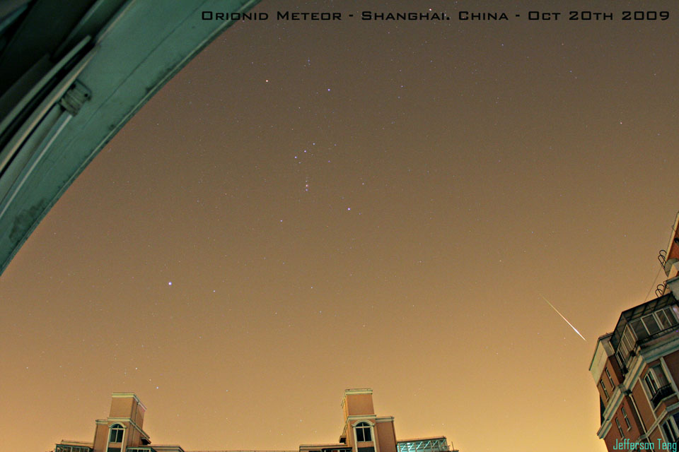
Hey bloggers. I have a developing update on the way. I just wanted to pop in real fast and let you all know that I have not forgot about you lol. This has been a busy week when it comes to blogging. I have had no time on the computer to make my forecast let alone blog. I have not even tweeted lately. :) Please stick with me bloggers. I promise I will have more frequent updates coming by Tomorrow. So check back tomorrow afternoon sometime and we will get back on track... Brow did let us know about a Meteor shower tonight! At least he's on top of things! LOL :) Take a look at this below.

ORIONID METEOR SHOWER: The Orionid meteor shower is underway. Earth is passing through a stream of dusty debris from Halley's Comet, and this is causing meteors to shoot out of the constellation Orion. Earlier today, amateur astronomer Jefferson Teng photographed an Orionid fireball over Shanghai, China:"I woke up early in the morning to observe the shower through my bedroom window," says Teng. "This one was quite bright considering the light pollution in Shanghai."
Forecasters expect the shower to peak on Wednesday, Oct. 21st, with dozens of meteors per hour. The best time to look is during the dark hours before sunrise. For best results, get away from city lights, but as Teng discovered, country darkness is not absolutely necessary.


One more thing! Have any of you noticed all the Yellow Ladybugs out lately? Wow there have been a LOT here in the greater Lafayette, area. What does this tell us when it comes to forecasting? I will let you know the story behind these Yellow bugs real soon. Brow also sends us a picture of these ladybugs. I will have that posted tomorrow as well. Thank you all for understanding the slow updates this week. I will check back here tomorrow with the Ladybug info. Until then continue to enjoy the mild temperatures! ;-)

Monday, October 19, 2009

The Weekend Felt Like A Winter Wonder Land!

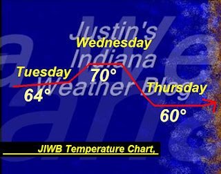
Well, as you all know I love the cold weather and we have seen nightly lows the past few night dropping into the low 30s. This has been great! However I'M in the mood for snow right about now! I'M really always in the mood fro snow however this past weekend I really got in the mood. Why is that? You ask. Well, Last Sunday as you all know was Football Sunday. I turned on the Titans game and take a look at what I found!That's right! New England had snow on the field!! It just don't get any better then this. It made it feel like winter had come early. And with our below average temperatures we have seen lately I'M sure some of you already feel it has. :) I will say and I'M sorry for all NE fans, But I don't like that team one bit. They killed the titans 59 to 0. They were up 45 to nothing in halftime. Now if that was me I would have taken out Tom Brady who is there starter QB and I would have put in the back up. Being up 45 to nothing in the 3rd quarter they were not going to lose. But NO they kept Tom in starting the 3rd and totally killed the titans. I don't feels that's right. They should at least leave the titans with some pride. It was such a blow out that they switched to a different game. That's bad! The score you see below was only the first of many.Now I did not pop in to only talk about football lol. This is a weather blog! But as you can tell Football in my favorite sport. Even more on Thanksgiving in snow! Ha Ha :) So I have been talking about the models showing a slight warm up this week. Has that held true? Well, at this point and time I can say we are looking for some middle to upper 60s this week starting tomorrow / Tuesday. Believe it or not after running around 15 to 17 degrees below average all month we will be right around average tomorrow. Yes, we are expected to see highs around 64°F degrees which is only one degrees below average give or take. Average for this time of year is around 65°F degrees. Here is the Temperature Chart below.Tuesday we are looking for Partly cloudy skies over the WLFI viewing area. The more north you go the more clouds you will likely see. We will look for highs in the low to middle 60s and lows in the low to middle 40s around 44°F degrees. Winds will be between 15 and 25 mph with a few gusts to 27 mph possible in open areas.

.

.

Wednesday we will see much of the same with more Partly cloudy skies over the WLFI viewing area. More clouds will move into the area later on Wednesday night into Thursday. Highs will be in the upper 60s to low 70s possible with lows in the middle to upper 40s closer to 48°F degrees. Winds will again be between 15 and 25 mph.

.

.

As for the next chance at rainfall, I don't see any rain in the forecast until closer to Thursday. So for the next few days we will see mild partly cloudy skies. The reason for the rain moving in on Thursday will be do to a stationary front that is just sitting over the Iowa area ta this time. This slow moving front will finally start to make a move on us by closer to Thursday. Currently not looking like a total wash out however as the front continues to develop and models become more clear I will have more info and expected rainfall totals posted.

.

.

And last but not least "How long will the mild temperatures last?" Well, At this time I look for a good four days of mild temperatures which will bring the cool 50s back by this weekend. Warm weather lovers get out and enjoy while you can.

.

.

Thank you for reading. Enjoy your Monday and I will check back soon.....

Saturday, October 17, 2009

Quick Weekend Pop In... Frost Advisory In Effect!

We have a frost advisory in effect for much of the WLFI viewing area. However counties like Benton, Newton, Jasper, and White are not under this advisory. We are looking for lows tonight to fall into the low 30s near freezing. Highs tomorrow will only be in the middle 50s. With these cool temperatures moving into the area tonight we will see frost in areas and more widespread frost in cooler areas. Here is the advisory posted below.

***Frost Advisory In Effect For The Following Below***


CARROLL-WARREN-TIPPECANOE-CLINTON-FOUNTAIN-MONTGOMERY-BOONE-
VERMILLION-PARKE-PUTNAM-HENDRICKS-MARION-VIGO-CLAY-OWEN-MORGAN-
JOHNSON-SULLIVAN-GREENE-MONROE-BROWN-BARTHOLOMEW-KNOX-DAVIESS-
MARTIN-LAWRENCE-JACKSON-JENNINGS-
INCLUDING THE CITIES OF...LAFAYETTE...FRANKFORT...
CRAWFORDSVILLE...INDIANAPOLIS...TERRE HAUTE...BLOOMINGTON...
COLUMBUS...VINCENNES...BEDFORD...SEYMOUR

SAT OCT 17 2009
...FROST ADVISORY IN EFFECT FROM MIDNIGHT TONIGHT TO 8 AM EDT
SUNDAY...

~~~~~~~~~~~~~~~~~~~~~~~~~~~
~~~~~~~~~~~~~~~~~~~~~~~~~~~~~~
Above is a quick look at the warm up that we talked about in my last blog post. I have gone through the weather data once again this evening and it is still calling for a slight warm up by the start of the work week. We are currently looking at temperatures possible in the upper 60s. This warm up won't last long so for those who enjoy the warmer weather, Get out and enjoy it while you can. Cool weather lovers hang in there as the cool will return! :) For now have a wonderful weekend bloggers.. I will check back soon..........

Friday, October 16, 2009

We Will Look At The Winter Outlook And Some More Cooler Temperatures.....

Hey bloggers. Long time no see. Well, I'M back now and I have a new blog update full of your weekend forecast and also a look at the latest winter outlook. First off I'M sorry for the lack of updates. It has been a busy week and I have had no time on the computer to go through all the weather data or time to blog. I have been out driving my Grandma around again today. However I have some time now so lets get to it while we can! :)

First off we started out the day again with some light scattered showers across the area. Not much! However here is a look at some rainfall totals from around the area below.

Remington, 0.13"

Rensselaer, 0.03"

Kentland, 0.02"

Williamsport, 0.02"

Lafayette, 0.02"

Attica, 0.01"
~~~~~~~~~~~~~~~~~~~~~~~~~
~~~~~~~~~~~~~~~~~~~~~~~~~~~~

As you can see most stayed around that Tenth inch mark or at least under the quarter mark. It has been a wet week that is for sure. I think it is time we have some dry weather don't you? Well, it is looking like we will get our wish this week. The weekend is looking good at this time with dry and partly cloudy skies on Sunday. However as for the Temperatures! Well, I can't do everything. :) On the other hand there are a few models pointing to a slight warm up coming next week. Not a major one however highs in the upper 50s to low 60s may be possible. It is a few days off so I will continue to watch that and keep up updated. Until then here is a look at your weekend outlook below.So really the weekend is looking pretty good with dry weather expected for the most part. Still cold yes. But I think we can handle that! ;) I'M not seeing any snow in the forecast this week however I'M sure it won't be far off! We have been a good 15 to 17 Degrees below average this whole month! As I type the Lafayette, current temperature is at 43.3° degrees. This is our average low for this time of year! Pretty amazing if you ask me! We called for a cold start to October and that has come true. For the next 8 to 14 days our temperatures will be about 50% below average. Keep those jackets out maybe even light coats. And put another blanket on the bed. Nights still dropping into the low 30s. Brrrrrrrrrrrrrrrrrrr Is the word of the day! Here is a look at the Winter temperature outlook below. You can see we are expected to see equal days of average and below average temperatures. As we look at this map and how our first few weeks of October have been we can see we will be cold enough for snow! However how many snow chances will we see? That is the big question. With this El-Nino jet stream pattern this winter we usually see the storm track set up more to our east. Will that be the case this year? Take a look at the winter precipitation outlook below.I love snow and cold weather so I will continue to look for it this season. (We have to see at least one good snow or I will be moving far north to MN, lol) :-) You can see we are pretty close to the drier / equal mark on this map. Does this mean I'M ruling out snow? No. I still think we have a good chance. It won't be like the winter of 2007 when we had the La-Nina jet stream pattern. La-Nina is when we see a wetter pattern take place over our area and there for more snowfall! The only bad thing was it stuck around into the Summer when storm season took place. We had a fun winter however it came with a price that is for sure. You can see the warmer water in this image below. This is the latest image taken on September 17th 2009.So for now we will get through a few more days of cold temperatures across the area. Then if the weather models hold true we will have a slight warm up coming your way. I will continue to watch this developing story and I will check back soon..... Thanks for reading....................

Wednesday, October 14, 2009

The First JIWB Weather Blog T-shirt! A Thanks To My Sister...

Hey everyone! Brow it's good to hear for you. Where have you been? :) You had the word SNOW in your comment! I will be sure to get to that soon. ;-)

It has been such a long day. I was out all day playing taxi like I said in my last post. Driving my Mom and G-ma all over town while my sis was at the covered bridge festable. I'M home now and feel like some rest before more weather tracking. It was raining pretty good earlier this morning around 10:00am or so. Cold as well. High was 46.4°F Degrees in Lafayette. Brrrrrrrrrrr. So before I check in later with the weather outlook as well a Snow cast for Brow! I wanted to show you all the first ever JIWB T-shirt my sis had made up for me at the covered bridge festable. I made this Logo on the Computer the night before she headed up. Tell me what you think!
I made this design and she got it on a Shirt. The color in this picture is not the best. The design is dark blue at the top becoming a light blue to the bottom. I thought an Ice look would fit good as I love cold weather and it had to do with weather! This is the back of the shirt. There is my weather blog URL in the front. I will be wearing this T-Shirt the next time I'M out to help promote it. It is a one of a kind and I wanted to see what you all thought! :-) A Big thanks to my sis for getting the JIWB Logo on a Shirt.

I will check back later on with a look at the extended forecast. Until then..........


Get Out The Heavy Jackets As Highs Don't Get Out Of The 40s! Brrrrrrrr I LOVE IT! :D

I have a busy day of running around to do today. I have the job of driving my mother and Grandma around town all afternoon! YEAH lol :) Na I don't mind. However This is just going to be a quick check in. Right now I'M here to tell you all about the cool temperatures we are going to be seeing today and tomorrow. Yes, for the next few days it is going to feel pretty chilly. We will want to bring out the heavy jackets and maybe even add another blanket to the bed. So just how cool are we talking for our highs?
Well, not as cold as it looks above lol however I just like that picture :-P Ha Ha. Models are pointing to highs having a hard time getting out of the upper 40s for the next few days. I have highs today around 48°F Degrees. Lows in the 30s. My sister will be at the covered bridge festable today. I have already told her about these cool temperatures and to make sure she stays warm. The heavy jackets will be needed that is for sure! I'M still getting color back in my hands from my trip to the feast lol. And if these cool temps in the 40s are not enough! I look for rain showers to over take much of the area today. Nothing to heavy however this will be enough to make it a moist cold trip for all heading down to the covered bridge festable. The last thing we need is for people to get sick!

Here is a look at your quick cast below.

Today will be a cold rainy day through out the WLFI Viewing area. We will look for scattered rain showers to move through our area today. Rainfall is not expected to be heavy however Models point to rainfall between a Tenth and a possible quarter inch in areas. Dress warm if heading to the covered bridge festable as highs will have a hard time getting out of the upper 40s. Highs expected to be around 48°F degrees. Lows around 38°F degrees. Winds will make it feel even cooler as they are expected to be between 10 and 20 mph with a few gusts to 25 mph possible.

Thursday we will keep in the chance for more scattered light showers possible. Mostly cloudy with a 40% to 50% chance at some scattered light hit and miss showers in the WLFI viewing area. Highs will again be cold around 46°F degrees. Lows around 38°F degrees. Winds will be a little more calm between 10 and 15 mph with gusts to 20 mph possible.


Well, I'M off to play taxi lol. I'll check back soon.....

Tuesday, October 13, 2009

It Was A Beautiful Cool Weekend... What's In Store This Week?

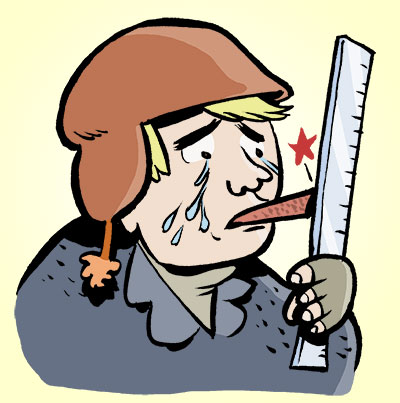
Hey bloggers. Did any of you get out to the Feast over the weekend? Well, I went on Sunday and I can tell you it was cold! lol Very cold. Before I went I thought about taking a winter coat, Then I thought "Well, it can't feel that cold out and it's a little to early for a winter coat" (WRONG) I don't think we hit 52° Degrees lol. My hands started to turn a dull color no joke. My nose looked like Rudolph the red nosed reindeer :) And the whole time I could not stop talking about how cold I felt lol. The good news is I was not the only one doing so. Now I love the cold as I have said here many times before. and I did enjoy myself so nature BRING ON MORE COLD!

We talked about going on Saturday however we went Sunday because of all the rain on Friday. It was nothing but mud on Saturday. Even when I went you could still see all the muddy mess from the day before. Take a look below at just one of the many mud holes that we passed.I had my camera phone ready to go taking many pictures of the blog however this is the only one I took. Reason? My hands got to cold to hold on to my phone! LOL And I was not going to risk dropping it into the mud. :) My Dad walked up to get some stew and ask I wanted any. I said "Nope" But that HOT Coffee looks pretty good right about now! And I have to say the coffee was the best part of the whole day! :) I spend so much time telling you all to dress warm and be safe in the weather events we have, That I forget to do the same myself Ha Ha :)Well, we had the Feast of the hunters moon last weekend and also the Covered bridge festable started last Friday. I know many many people head down there to Parke county this time of year to hit the deals and enjoy the scenery. I know my Mom, Sister, Aunt, and Uncle, will all be heading down there this week. My sister has made it real clear the thing she love the most about heading down to the covered bridge festable. And that is the drive down there. Because this time of year we see many trees changing colors. Reds, Orange, Yellow, you name it! Just like this picture I just took yesterday from my front yard.Fall is here however I think my tree is always the last to change. I have already had a few jobs to do with leave removal this month. It has come fast do to all the below average temperatures we have seen and also the cloudy days. The beautiful colors will be visible as you head down there. However if your not heading to the covered bridge festable and still want to see all the leaves without leaving home then have I got something for you! I always have a trick or two.

For those who don't want to drive to see the fall colors then you can just click the link below.

This link is a link to all the Indiana leaf cams in our area! Pick one and enjoy. It's that easy! And for anyone who has some fall pictures, Feel free to send them to me at storm18mini@aol.com and I would love to see them. Maybe even post them! Thanks ahead of time.....

And last but not least, How does the forecast look today? Well, lets take a quick look below.

Today we will look for some Partly cloudy skies across the WLFI viewing area through out much of the day. As we head into this evening into tonight we will see the clouds on the increase. We will look for highs today in the low to middle 50s and lows tonight drop into the upper 30s once again. I look for winds to be light between 10 and 15 mph.

Wednesday we will see something a little different. Yes, I look for mostly cloudy skies with a 20% to 30% chance of a stray scattered shower not out of the question. Rainfall would be light however I cannot rule rain out. We will see highs in the upper 40s to low 50s. COOL is the word of the day! Lows will be in the middle 30s. If heading down the the covered bridge festable be sure to have a heavy jacket handy! As well as a umbrella just in case.....

Thanks for reading Bloggers. I will check in again soon..........

Monday, October 12, 2009

What Are We Talking About This Week?

Good afternoon bloggers. I'M just popping in real fast to let you know what we will be talking about this week. First off we will talk about a chilly next week with temps not getting out of the 50s and lows in the low to middle 30s at night. We also have another low pressure system bringing rain back into our forecast! How much? We will look into that as well. And also I have a muddy picture from my day at the feast of the hunters moon yesterday! All this will be coming up soon. Right now I have to go get some work done for my neighbors...

I hope you all had a wonderful weekend. I want to hear all about it! :-)

Saturday, October 10, 2009

Quick Weekend Update! The Frost Is HERE! Cover The Plants...

Hey everyone. Here is your quick weekend post. You can see I got a few FINAL totals from around the area and above really show just how much rain we seen. (To Much) is the word today! We called for rainfall between an inch and a half to two inches with a few areas closer to tow and a half inches with locally higher amounts on top of that. Most of us stayed around that range however one number really sticks out up there. Yes, Mellott coming in with a final total of 4.90" inches! Almost five inches. That is just crazy in my book lol. Also we have seen the nights dropping into the middle 30s lately! How long is that going to last? Well, take a look at this below!
Freeze Warning In Effect For The WHOLE WLFI Viewing Area From 4:00am To 9:00am EDT Sunday..... Below Are Some Of Our Northern County Warnings And Times.....
.
.
Freeze Warning In Effect For The Following Counties Below.
Newton, Benton, Jasper, Counties.....
...FREEZE WARNING REMAINS IN EFFECT FROM 11 PM CDT /MIDNIGHT EDT/
THIS EVENING TO 9 AM CDT /10 AM EDT/ SUNDAY...
~~~~~~~~~~~~~~~~~~~~~~~~~~
~~~~~~~~~~~~~~~~~~~~~~~~~~~~~~
.
.
And A Freeze Warning In Effect For The Following Counties.
Cass, White, Counties.....
...FREEZE WARNING REMAINS IN EFFECT FROM 4 AM EDT /3 AM CDT/ TO
9 AM EDT /8 AM CDT/ SUNDAY...
~~~~~~~~~~~~~~~~~~~~~~~~~~~
~~~~~~~~~~~~~~~~~~~~~~~~~~~~~~
.
.
Yes, the Frost is here! This warning means we could drop to or below the freezing mark tonight and this could kill crops or other vegetation areas. Be sure to ether bring your plants inside or at least cover them. I have taken a look into next week and we will be seeing these cool night pretty much from here on out. Yes, we have been running at least 10 to 12 degrees below our average high for this time of year! Is this a sign of whats to come this winter?

Well, today we have sunny skies outside which is a change from what we have been seeing the past few days. It is a good day to head down to the Feast of the Hunters moon. Or if you want the ground to dry out a little then Tomorrow I also look for some Partly cloudy skies! It will fee a little chilly so if your heading down there you may want to bring a jacket of some kind!

Have a wonderful weekend bloggers. I will be sure to check in again soon..........

Friday, October 9, 2009

Crazy BIG Numbers! How Much More Can We Expect?

Heavy rainfall across the area has given way to some BIG Numbers! Some bigger then others! I thought Lafayette had a good number until I just got a report from Mellott, In Fountain county. They have seen rainfall around 4.00" inches. Onw of the biggest I have seen in our viewing area. Most of us have picked up around one to two inches in the WLFI Viewing area. Here are the number at this time and remember it is still coming down right now!

Mellott, 4.00" Inches


Lafayette, 2.40" Inches

Williamsport, 1.99" Inches

Attica, 1.96" Inches

Remington, 1.28" Inches

Kentland, 1.21" Inches

Monticello, 1.16" Inches
~~~~~~~~~~~~~~~~~~~~~~~~~~~
~~~~~~~~~~~~~~~~~~~~~~~~~~~~~~~~~

There is still so much moisture being pulled into this system that I would not count out another quarter to a half inch possible in areas.

Now I'M still watching the rivers like crazy however we are currently at 3.17ft on the Wabash river. We are still expected to creast on Sunday at 2:am at around 7.7" ft. This is not flood stage however it is Action stage! So we will continur to keep watch! Here is a look at the radar image as of 12:07PM EDT.

We can't wait for that lighter rain to move over our area for a while! :) We have been going crazy for raun however this may just be a little to much! ;-) I will continue to watch things closely! And I will keep you posted as needed. Stay dry and drive safe..........